
13 min read
Kayak Meteorology Training – Lifesaving Knowledge
While the kayak is a self-propelled craft that can navigate the elements efficiently, there are instances—especially during expeditions in remote areas—where meteorology and navigation become crucial resources.
Consequently, it is essential to acquire a fundamental understanding of meteorology. This knowledge enables us to anticipate unpredictable situations and learn how to evade them.
This guide serves as a crash course in kayaking meteorology, aiming to equip you with the tools necessary for success.
We typically encounter three atmospheric variables.
Temperature, Pressure. Humidity
Changes to these variables usually tell us what conditions are available for kayaking. In practical terms, the temperature and pressure are readily available using a bracelet or a GPS, but we can determine the moisture measurement from our predictions for our purposes.
In general, a drop in barometric pressure *2-3 mbar in 3 hours will indicate that bad weather is coming if the drop is very rapid and pronounced *5 or more millibars in 3 hours. That means a weather phenomenon is fast approaching, and the temperature will tell us whether the front is cold or warm, which will usually determine rainfall.
Similarly, a barometric rise indicates improvements in the weather. If the temperature is low, we will have polar winds. Whereas if it goes up. We will have hot and dry weather.
Concerning humidity. It is interesting to know the dew point since when the temperature falls below this, the humidity of the environment begins to condense or mist or fog.
| Pressure | Temperature | Prognosis |
| Dropping | Dropping | Abundance of rain |
| Dropping | Stable | Probable rain |
| Dropping | Rising | Weather may vary |
| Stable | Dropping | Probable rain |
| Stable | Stable | Weather may vary |
| Stable | Rising | Good temperature |
| Rising | Dropping | Polar winds |
| Rising | Stable | Good temperature |
| Rising | Rising | Hot and dry temperature |
If you’re in the market to buy something to do this, we recommend the following two products for measurements (if you don’t need a GPS included).
Kestrel 4500 Weather & Environmental Meter
Kestrel 2500 Pocket Weather Meter
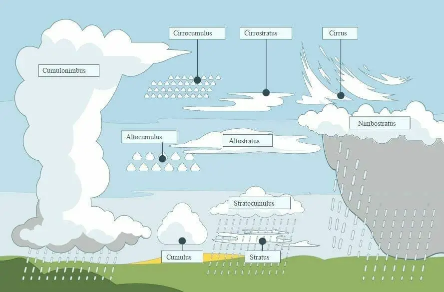
Clouds
Are another indicator of the state of the current weather and weather to come. Cirrus, stratus, and cumulonimbus clouds are classified by shape and can be combined at different heights to form zero Cumulus alto and stratus cumulus clouds.
Characteristics of Different Cloud Types
| Cloud Type | Indication of Weather |
|---|---|
| Cirrus | Indicator of fair weather, but can suggest a weather change if they thicken |
| Stratus | Generally bring continuous rain or snow, depending on the temperature |
| Cumulonimbus | Associated with heavy weather, thunderstorms, rain, and even tornadoes |
Each cloud type and succession of clouds indicate with some precision what type of weather lies ahead. Learning to recognize them and make your projections and observations is very useful.
We can red flag bad weather when the cirrus uncinus cloud is approaching that bad weather will be present within 48 hours; Nimbostratus and cumulonimbus may lead to thunderstorms. The prefix and suffix Nimbus refer to a cloud that produces precipitation; also, a large solar or lunar Halo reflection of crystal or ice indicates that snow or rain may be ahead.

Characteristics of Different Cloud Types
| Cloud Type | Indication of Weather |
|---|---|
| Cirrus | Indicator of fair weather, but can suggest a weather change if they thicken |
| Stratus | Generally bring continuous rain or snow, depending on the temperature |
| Cumulonimbus | Associated with heavy weather, thunderstorms, rain, and even tornadoes |
The combination of different signals can give you greater certainty in predicting the weather to come. Identifying a single indicator to make good predictions is usually insufficient. You must use varied knowledge and various signals to determine what weather lies in store.
Wind
The Sun comes out everywhere, but it does not heat all the parts of the world in the same way.
General Impact of Wind Speed on Kayaking
| Wind Speed (knots) | Effect on Kayaking |
|---|---|
| Up to 10 | It will not affect the ride |
| Above 20 | Causes issues for tipping kayaks |
| Around 30 | Virtually prevents the advance of a kayak |
Either by the inclination of the earth’s axis, causing different weather, or because the different surfaces absorb heat differently. The result is that the atmosphere is in constant motion. The air is heated and rises, leaving a space that has to be occupied, and air masses begin to circulate, generating and transporting moisture. These are the dynamics essential for life on earth and for sailing sports.
It is an inevitable obstacle for kayakers on our trips, and we should pay as much attention to it as possible.
These pressure differences in the atmosphere produce a displacement of high air pressure towards low pressure coupled with other factors such as gravity, Coriolis forces, centrifugal force, and friction, generating changes that will determine our trip through the water. The wind is determined by the intensity or the force that blows and the direction from which it comes.
We normally find it shown in knots * 1knot = 1-mile marina/h = 1.85km /h, and the direction is based on the direction of the rise of the winds *N, NE, E, S, SW, W, NW.
Beaufort Scale
To simplify things, Sir Francis Beaufort, an English sailor, developed an empirical scale based on the effects of the wind on sails, which was later assimilated to the effect of it on the sea and associated with the intensity of the wind measured by a anemometer. And so was born the Beaufort scale, and below we see it associated with the Douglas scale for its effect on the sea.
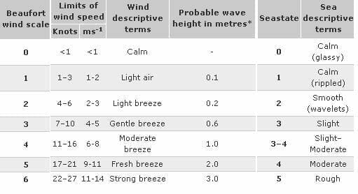
In short,
0-3, go ahead and row happy,
3 to 4. The fun starts,
5. The experienced have fun,
Six, you should be experienced to try this.
As we have seen, the waves are produced by the wind. How much time and strength the wind blows on the waves without obstacles develops the wave. In a Lake, the waves will be larger on the shore where the wind blows in the sea. It’s complicated, as there may be a sea of wind (caused by wind waves) and a sea of background (waves that travel from distant storms), not necessarily in the same direction.
Given that kayaks usually sail close to the ground, we must also consider the effect of geography on the wind to find the most protected shores or avoid wind corridors.
Another aspect to consider is that the wind on the shore is always less than offshore since terrestrial obstacles affect the wind both Windward (wind up) and Leeward(downwind) and depending on the height of the obstacle.
In inland lakes, winds may differ from sea winds. There are phenomena of local winds caused by thermal differences rather than isobaric gradients. The most common is the sea breeze blowing from the sea inland (wind W) once the Sun begins to warm and blowing during the night towards the coast (wind E).
They are also common in mountainous areas. The winds come down the slopes of the mountains, producing turbulence and reaching dangerous levels in the areas of glaciers where they are known as williwaws and can reach 120 knots.
The wind is the main atmospheric element that affects us.
Ten knots will not affect our ride,
while higher than 20 already causes issues for tipping kayaks.
And the 30s virtually prevent the advance of a kayak.
Take this information with special consideration for going(or not) to go rowing.
As an example, the climate of the Pacific is determined mainly by two major geographic features: the Pacific Ocean and any mountainous areas. Because mountains are so narrow, some countries on the Pacific essentially have a marine climate, but the different geographic and oceanographic characteristics make them different throughout the area. We have various climatic zones, with rainfall ranging from 0.0 mm in the desert and 8,000 mm in more southern areas of the Americas.
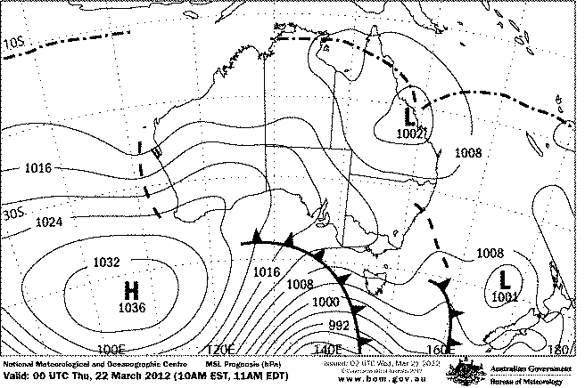
Interactions are evident when examining the synoptic chart: Remember that low-pressure centers suck air masses, producing a movement (wind) that rotates clockwise toward the Center, while the center with high-pressure expels air that rotates counterclockwise, away from the Center.
Synoptic Chart Reading
The Synoptic chart shows high-pressure centers (marked with an H) and low-pressure centers (marked with an L or l).
Filler lines represent places with the same atmospheric pressure, so the closer these lines, the greater the winds, moving circularly from or toward the Center and usually at an angle of 25 ° – 35 ° of the Isobar.
Low-pressure centers bring fronts of bad weather that normally move w to E.
Navy Notices
The Meteorological Department of the Navy issues a notice every 12 hours or a weather prognosis. This can be obtained from the navy website, via phone by calling any port authority, or via band radio marina with any radio station.
Understanding Navy Weather Report Terms
| Term/Description | Meaning |
|---|---|
| SITUATION SYNOPTIC | Describes the current large-scale atmospheric pressure pattern |
| FORECAST | Expected future conditions |
| VIS | Visibility in kilometers |
| VTO S/SW 10/20 NDS | Wind coming from the south/southwest at 10 to 20 knots |
| SEA LEVEL ACURLY AT BAY WITH BEACHCOMBER IN COASTLINE OPEN TO THE SOUTHWEST, COARSE TO VERY COARSE (3.5/5.0 METERS) AS THE SOUTHWEST IN AREA OCEAN SWELL | Description of the state of the sea |
| UV INDEX: 1-2 UNDER (DMC SUPPLY) | Ultraviolet (UV) radiation level, on a scale from 1 (lowest) to 11+ (highest) |
| MARGIN ANTICYCLONIC | Presence of high-pressure systems |
| APPRECIATION IS VALID FROM 072000 UNTIL 080800 LOCAL TIME | Duration of forecast validity |
On long expeditions, it is important (and mandatory) to have a band radio and a list of the stations and bases along your route.
What you get as an example could be as follows.
REPORT WEATHER MARITIME TO LA JOLLA SAN DIEGO.
VALID FROM 070800 UNTIL 072000 LOCAL TIME.
SITUATION SYNOPTIC:
UNSTABLE TO MARGIN ANTICYCLONIC.
FORECAST:
PARTIAL TO CLEARED, VIS 10 KMS, VTO S/SW 10/20 NDS, SEA LEVEL ACURLY AT BAY WITH BEACHCOMBER IN COASTLINE OPEN TO THE SOUTHWEST, COARSE TO VERY COARSE (3.5/5.0 METERS) AS THE SOUTHWEST IN AREA OCEAN SWELL.
PROBABLE MAXIMUM TEMPERATURE: 14° C
UV INDEX: 1-2 UNDER (DMC SUPPLY).
APPRECIATION IS VALID FROM 072000 UNTIL 080800 LOCAL TIME.
MARGIN ANTICYCLONIC, VTO S/SW 6/12 NDS.
The Data first explains to us which area the report pertains to. In this case, La Jolla San Diego. It may also be given in areas we must identify on the map since they reference ports, lighthouses, and Islands. Then it indicates the validity of the forecast period, the date and the local time (070800 = 7th, 08:00 hours), and then the general synoptic situation in the area, the presence of frontal systems, and pressure centers.
Then it reports the outcome where we can identify the following:
PARTIAL TO CLEARED. Cloudiness is measured in eighths. Clear is up to 1/8 of the sky with clouds, partial is 2/8 to 4/8, cloudy is from 5/8 to 7/8 and covered is the sky with clouds.
VIS 10 KMS, VTO S/SW 10/20 NDS ROLANDO SECTOR South NW/N 8/16NDS, visibility 10 kilometers and 10 to 20 knots of the S/SW.
SEA LEVEL A CURLY AT BAY WITH BEACHCOMBER IN THE COASTLINE OPEN TO THE SOUTHWEST, COARSE TO VERY COARSE (3.5/5.0 M) AS THE SOUTHWEST IN AREA OCEAN SWELL. State of the sea
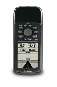
If you want to apply this information on top of the temperature recommendations, we recommend purchasing a GPS. A possible recommendation is the Garmin 72H Waterproof Handheld GPS with High-Sensitivity.
Weather Tips
| Weather Parameter | Tips for Kayaking |
|---|---|
| Temperature | Cold fronts usually determine rainfall; Polar winds occur when temperature is low, whereas hot and dry weather occurs when temperature rises |
| Pressure | Drop in pressure indicates coming bad weather, rapid drop could mean a fast-approaching weather phenomenon; Barometric rise indicates improvements in weather |
| Humidity | Knowing the dew point is important; when temperature falls below the dew point, environment humidity begins to condense, causing mist or fog |
| Wind | Wind direction and strength greatly affect the kayaking experience; Local winds in inland lakes or mountainous areas can produce turbulence and reach dangerous levels |
| Clouds | Different cloud types indicate the type of weather ahead, learning to recognize them can be very useful for planning |
| Synoptic Chart | Shows high-pressure centers (H) and low-pressure centers (L); Closer filler lines indicate greater winds |
Weather Terms Glossary
Here is a glossary of weather-related terms for kayaking:
- Barometric Pressure: The weight of the atmosphere as it pushes down upon the Earth’s surface. It is measured in units called millibars (MB).
- Cold Front: The boundary of an advancing cold air mass displaces warmer air. This often results in rainy weather.
- Coriolis Forces: The apparent force that, as a result of the Earth’s rotation, deflects moving objects (such as air masses) to the right in the Northern Hemisphere and to the left in the Southern Hemisphere.
- Dew Point: The temperature at which air becomes saturated (100% relative humidity) and water vapor in the air begins to condense into liquid water (dew), fog, or clouds.
- High Pressure Center (Anticyclone): A region where the atmospheric pressure is greater than the surrounding area. Usually associated with clear, calm weather.
- Humidity: The amount of water vapor in the air.
- Isobar: A line on a weather map connecting places with equal atmospheric pressure.
- Knot: A unit of speed used in aviation and marine contexts, equal to one nautical mile per hour.
- Low Pressure Center (Cyclone): A region where the atmospheric pressure is lower than the surrounding area. Usually associated with stormy weather.
- Meteorology: The scientific study of the atmosphere and its phenomena, especially in relation to weather and weather forecasting.
- Sea Breeze: A breeze blowing toward the land from the sea, often during the day due to the temperature difference when the land surface is warmer than the sea surface.
- Synoptic Chart: A weather map that shows the distribution of meteorological features over a specific area at a specific time.
- Thermal: A column of rising air in the lower altitudes of the Earth’s atmosphere. Thermals are created by the uneven heating of the Earth’s surface.
- Warm Front: The boundary of an advancing mass of warm air, which displaces cooler air. This often results in cloudy, but not overly stormy, weather.
- Windward: The direction from which the wind is coming.
- Leeward: The direction toward which the wind is blowing.
- Williwaws: A sudden blast of wind descending from a mountainous coast to the sea, often seen in the areas of glaciers.
Remember that understanding these terms can help you better understand weather forecasts, which can be crucial for safe and enjoyable kayaking experiences.